


وصف لـ Hiking Slovakia - Tourist Map
Hiking app covering the area of Slovakia. A must-have for every hiker.
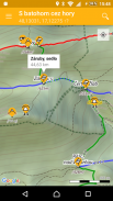
• All marked hiking trails and junctions
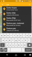
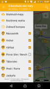
• Large database of peaks, viewpoints, picnic or camping sites, castles, caves, water sources, shelters or accomodations
• Elevation and contour maps with scale
• Ability to download maps to phone and use them offline
• Indication of current location
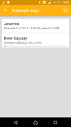
• The distance to any point
• Search among the junctions and other points of interest
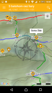
• Augmented reality for better orientation in the terrain
• Compass
Warning: If you like being lost, love adrenaline and survival, don't get this app... ;-)
Required permissions: location (see the current position on map), Internet access (maps), access to the SD card (locally stored maps), camera (augmented reality)
The application uses freely available data from projects freemap.sk and openstreetmap.org
المشي لمسافات طويلة التطبيق يغطي منطقة سلوفاكيا. ويجب أن يكون لكل مسافر.
• جميع مسارات المشي ملحوظ وتقاطعات
• قاعدة بيانات كبيرة من قمم، ووجهات النظر، ونزهة أو التخييم المواقع والقلاع والكهوف، ومصادر المياه، والملاجئ أو المباني
• الارتفاع وكفاف الخرائط بمقياس
• القدرة على تحميل الخرائط على الهاتف واستخدامها حاليا
• بيان الموقع الحالي
• المسافة إلى أي نقطة
• ابحث بين التقاطعات وغيرها من النقاط المثيرة للاهتمام
• زيادة واقع لتوجيه أفضل في التضاريس
• بوصلة
تحذير: إذا كنت تحب الضياع، الحب الأدرينالين والبقاء على قيد الحياة، لا تحصل على هذا التطبيق ... ؛-)
الأذونات المطلوبة: موقع (راجع الموقف الحالي على الخريطة)، الاتصال بشبكة الإنترنت (الخرائط)، والوصول إلى بطاقة SD (الخرائط المخزنة محليا)، وكاميرا (الحقيقة المدمجة)
يستخدم التطبيق البيانات متاحة بحرية من freemap.sk المشاريع وopenstreetmap.org
Hiking Slovakia - Tourist Map - إصدار 3.0.10
(26-03-2022)
Hiking Slovakia - Tourist Map - معلومات APK
نُسخة APK: 3.0.10الحزمة: sk.archae.hiking.androidتطبيقات من الفئة نفسها
قد يعجبك أيضًا...


